Zion Narrows Top Down Hike in Summer
"When you really want something, the entire universe
conspires to help you achieve it ~ Paulo Coelho"
I do not know how else to begin this post except with this quote. I first set my eyes on Narrows during our Thanksgiving trip to Zion National Park in 2012. We did the Angel's Landing Hike then and decided to come back for the Narrows hike in summer when it would be more fun to hike in the water. Come back we did, 7 years later during the July 4th weekend, and what a fun hike it was! Narrows top down hike involved 16+ miles of wading through water, sometimes chest deep and at times swimming, crossing the river flowing at a rate of nearly 80 cubic feet per second (cfs) innumerable times and walking on slippery boulders and uneven grounds throughout. All of this as the majestic walls of the canyon gradually close in around you to form the mesmerizing "Narrows". I felt incredibly lucky to be walking in that virgin river between those canyon walls, though it is hard to explain why. But what I can definitely tell you is that it was much more than a hike - a challenge we enjoyed thoroughly and an adventure we will remember forever. If you are an adventure seeker and a hiker, this should be on your list.
There are several ways to hike the Narrows:

There are several ways to hike the Narrows:
- Bottoms-Up hike: Take the park shuttle to the Temple of Sinawava (last shuttle stop in the Park), walk a mile on the paved Riverside Walk and hike the Narrows to the Big Spring area and back. This would be a 10 mile round-trip hike to the shuttle stop and is usually referred to as the Narrows Bottom-up hike. This does not require any permit and is very flexible as you can turn back anytime. We saw several people in the first mile and they gradually decline in numbers and only a handful of people make it all the way to the Big Springs area.
- Top down hike in one day: It is a 16 mile one way hike in the Virgin river from Chamberlain's Ranch (which is outside the Park) all the way to the Temple of Sinawava. This hike requires a permit and you can do it as a day hike.
- Top down hike in 2 days: You can stay overnight at a wilderness campsite (no facilities) along the trail and do it as a 2-day hike. This would be a backpacking trip and you would need both a permit and campsite reservation.
We did the Narrows top down hike in one day.
Planning & Logistics:
Now, planning for the Narrows top down hike is a bit tricky. Here's why:
- First, you need to reserve the permits 2 months in advance. You can reserve them here.
- Second, the actual permits are issued and the top down hike is open only when the water flow is less than 120 cubic feet per second (cfs). Water flow is highest in early spring and winter, moderate in summer and lowest in the fall. You can check the water flow here.
- Third, there is a higher risk of flash floods in summer which can be dangerous while in the Narrows as there is no way to get to a high ground quickly in some places. So, you need to make sure there is no rain forecast during the week you plan to hike. There is also a flash flood forecast available 48 hours in advance and you can check it here.
- Fourth, under favorable conditions (when water level is below 70 cfs), the 16-mile route takes an average of 12 hours as per the National Park website. The top down hike starts at Chamberlain Ranch which is about 1.5 hours from Zion Visitor Center and if you hire a shuttle service (you would, unless you have 2 vehicles as it is a one-way hike), the earliest you can get to the starting point is around 8 am. From March through late November the shuttle runs daily in Zion Canyon and no private vehicles are allowed on the Zion Canyon Scenic Drive during this period. The last shuttle bus from Temple of Sinawava departs at 9:15 pm from early May through late September and at 7:15 pm from late September through late November which is a pretty tight time frame for this hike, especially in the fall.
- Fifth, water temperatures tend to be between 40-50F in early spring, fall and winter and between 55-65F in summer.
Considering all the above, when the permits opened on May 5th for the month of July, I made a reservation for 4 people for the top down Narrows hike for July 5th. The water flow was around 600 cfs when I made the reservation. Since then I had been checking the water flow at least twice a day and even more frequently as we got closer to our hike date. The water flow did not show any signs of decline until the beginning of June due to the long snow season this year. The water level began to decline in the second week of June and just as we were getting our hopes up, there was a flash flood in the third week of June. We debated several times if we should cancel this hike and make other plans, but somehow stuck around. Finally, the water level came down to 120 cfs and the top down hike opened on June 26th, just a week before our trip. The chart below convinced me that the universe conspired to make this happen just in time for our trip :)

I was constantly in touch with Zion Adventure Company and Zion Rock & Mountain Guides for local updates (on rain and snow in the region and they were helpful in sharing their insights) and finally made the shuttle reservation with Zion Rock & Mountain Guides as they pick you up from Zion Visitor Center at 6:30 am and drop you at the trail head around 8 am. You can park your car at the Visitor Center Parking lot where the free park shuttle from Temple of Sinawava will drop you after your hike.
Equipment & Rental:
Apart from the permit and the shuttle reservation, it is highly recommended to rent the canyoneering boots, neoprene socks and a hiking pole for this hike in summer. During winter, you would also need a wetsuit along with the above. We bought our own neoprene socks and hiking poles and rented the canyoneering boots from Zion Outfitters which is near the Zion Visitor Center. On the day of our hike, water flow was between 75-80 cfs and water temperature was around 49F, not exactly the summer conditions you would expect. A hiking pole was almost mandatory on this hike to gauge the depth of water before you stick your feet in as the river bed is highly uneven and the water isn't always clear enough. The neoprene socks and the boots helped keep our feet reasonably warm throughout the hike and the boots also provided good ankle support. Due to the several slippery boulders on the river bed, there is a good chance of you twisting your ankle and these boots will help minimize that. You could also rent a dry bag to keep your stuff dry but we used zip lock bags for most of our stuff and a waterproof case for our phone.
Packing - Food, Water & Others:
We each carried 2-3 liters of water, 4 protein bars, 2 GU packs, 2 propel electrolyte powder packets and 2 salt packets along with lunch.
We also carried our phone, ID card, permit, hat, sunglasses, waterproof light jacket, band-aids, painkillers and a Restop 2 solid waste bag to carry out our poop (though we can pee in the river, we are required to carry out our own poop and there are no restrooms along the hike or at the campsites).
The hike:
8:00 am:
Our shuttle dropped us off at the trail head near Chamberlain's Ranch around 8 am. There is a vault toilet there that we felt compelled to use knowing that there will not be any restroom throughout the hike. Though there were other people in the shuttle with us, we barely saw them throughout the hike as they were camping overnight and hence had a more relaxed pace.
8:15 am:
We began the hike around 8:15 am by crossing the virgin river and walking along a dirt road amidst greenery. After a couple of miles into the hike, there was a private gate which we had to pass through.
9:15 am:
Around 9:00 am, we saw a dilapidated hut on our left which is referred to as 'Bullock's Cabin' in the trail map. We continued on the dirt trail as long as we could until we had to descend into the water 10-15 minutes later. This is the first place where we entered the river after that initial crossing.

For the next 3 hours, we crisscrossed the river to hike on the shoreline trails along the river bank to pick up speed lost while hiking in the water. However, it is recommended not to stray far away from the river's edge to avoid damaging the fragile plant life.


12:15 pm:
Around 12:15 pm we reached the North Fork Falls. There is a little passage on the left side to cross these falls area. We then stopped for lunch for 15 minutes in a shaded area that came after these falls.

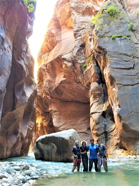
The scenery was quite dramatic for the next couple of hours. The canyon walls grew taller and got closer as we walked further. It was just the 4 of us in those canyons for most of the time, making it quite a serene and wonderful experience.


2:15 pm:
We crossed several campsites over the next 2 hours and reached the Big Springs area around 2:15 pm. Right before we reached the Big Springs area, the river flow increased significantly, so we went through campsite 12 to pass this area. Luckily, the campsite is not occupied, so it made it easy for us to cross this area safely to reach Big Springs.

Soon after, we reached the Wall Street and were so excited that we took a dip in the water and swam a bit. It was so refreshing. Wading through knee deep waters on slippery boulders in the Wall Street was akin to going on a pilgrimage for me. No wonder the end point of this hike is called the 'Temple of Sinawava' :)
The water levels kept increasing for the next couple of hours and were up to chest level in some places. There were a couple of places where we had to strategically choose our path so as to not drown ourselves and having a good team was quite helpful. We did slip occasionally when crossing the river but felt safe overall.
5:15 pm:
We reached the Orderville Canyon a few hours later. There are no trail markers anywhere along the hike and our smart devices counted distances much much longer than what we actually covered on the hike as we constantly kept crisscrossing the river to find shallow areas. So, it was hard to tell how far we have come and how much more there is to go. We tried asking the people coming in the other direction but got a wide range of responses.

6:30 pm:
We reached an open area around 6:30 pm and knew we were close enough. We took a short break here before our last mile or so in the canyon. I was already sad that our time in the canyon was coming to an end.

7:15 pm:
We reached the riverside walk around 7:15 pm and the shuttle stop at 7:30 pm. Luckily, there was no queue at the shuttle stop and we were back at the visitor center by 8 pm.
It was a long but fulfilling day. We were tired but happy. We had a couple of bruises but a lot of smiles. As always, the company of my husband and friends made the journey far more worth it. 3 cheers to the team that made it!

I was constantly in touch with Zion Adventure Company and Zion Rock & Mountain Guides for local updates (on rain and snow in the region and they were helpful in sharing their insights) and finally made the shuttle reservation with Zion Rock & Mountain Guides as they pick you up from Zion Visitor Center at 6:30 am and drop you at the trail head around 8 am. You can park your car at the Visitor Center Parking lot where the free park shuttle from Temple of Sinawava will drop you after your hike.
Equipment & Rental:
Apart from the permit and the shuttle reservation, it is highly recommended to rent the canyoneering boots, neoprene socks and a hiking pole for this hike in summer. During winter, you would also need a wetsuit along with the above. We bought our own neoprene socks and hiking poles and rented the canyoneering boots from Zion Outfitters which is near the Zion Visitor Center. On the day of our hike, water flow was between 75-80 cfs and water temperature was around 49F, not exactly the summer conditions you would expect. A hiking pole was almost mandatory on this hike to gauge the depth of water before you stick your feet in as the river bed is highly uneven and the water isn't always clear enough. The neoprene socks and the boots helped keep our feet reasonably warm throughout the hike and the boots also provided good ankle support. Due to the several slippery boulders on the river bed, there is a good chance of you twisting your ankle and these boots will help minimize that. You could also rent a dry bag to keep your stuff dry but we used zip lock bags for most of our stuff and a waterproof case for our phone.
Packing - Food, Water & Others:
We each carried 2-3 liters of water, 4 protein bars, 2 GU packs, 2 propel electrolyte powder packets and 2 salt packets along with lunch.
We also carried our phone, ID card, permit, hat, sunglasses, waterproof light jacket, band-aids, painkillers and a Restop 2 solid waste bag to carry out our poop (though we can pee in the river, we are required to carry out our own poop and there are no restrooms along the hike or at the campsites).
The hike:
8:00 am:
Our shuttle dropped us off at the trail head near Chamberlain's Ranch around 8 am. There is a vault toilet there that we felt compelled to use knowing that there will not be any restroom throughout the hike. Though there were other people in the shuttle with us, we barely saw them throughout the hike as they were camping overnight and hence had a more relaxed pace.
8:15 am:
We began the hike around 8:15 am by crossing the virgin river and walking along a dirt road amidst greenery. After a couple of miles into the hike, there was a private gate which we had to pass through.
9:15 am:
Around 9:00 am, we saw a dilapidated hut on our left which is referred to as 'Bullock's Cabin' in the trail map. We continued on the dirt trail as long as we could until we had to descend into the water 10-15 minutes later. This is the first place where we entered the river after that initial crossing.

For the next 3 hours, we crisscrossed the river to hike on the shoreline trails along the river bank to pick up speed lost while hiking in the water. However, it is recommended not to stray far away from the river's edge to avoid damaging the fragile plant life.


12:15 pm:
Around 12:15 pm we reached the North Fork Falls. There is a little passage on the left side to cross these falls area. We then stopped for lunch for 15 minutes in a shaded area that came after these falls.

The scenery was quite dramatic for the next couple of hours. The canyon walls grew taller and got closer as we walked further. It was just the 4 of us in those canyons for most of the time, making it quite a serene and wonderful experience.


2:15 pm:
We crossed several campsites over the next 2 hours and reached the Big Springs area around 2:15 pm. Right before we reached the Big Springs area, the river flow increased significantly, so we went through campsite 12 to pass this area. Luckily, the campsite is not occupied, so it made it easy for us to cross this area safely to reach Big Springs.

Soon after, we reached the Wall Street and were so excited that we took a dip in the water and swam a bit. It was so refreshing. Wading through knee deep waters on slippery boulders in the Wall Street was akin to going on a pilgrimage for me. No wonder the end point of this hike is called the 'Temple of Sinawava' :)
The water levels kept increasing for the next couple of hours and were up to chest level in some places. There were a couple of places where we had to strategically choose our path so as to not drown ourselves and having a good team was quite helpful. We did slip occasionally when crossing the river but felt safe overall.
5:15 pm:
We reached the Orderville Canyon a few hours later. There are no trail markers anywhere along the hike and our smart devices counted distances much much longer than what we actually covered on the hike as we constantly kept crisscrossing the river to find shallow areas. So, it was hard to tell how far we have come and how much more there is to go. We tried asking the people coming in the other direction but got a wide range of responses.

6:30 pm:
We reached an open area around 6:30 pm and knew we were close enough. We took a short break here before our last mile or so in the canyon. I was already sad that our time in the canyon was coming to an end.

We reached the riverside walk around 7:15 pm and the shuttle stop at 7:30 pm. Luckily, there was no queue at the shuttle stop and we were back at the visitor center by 8 pm.
It was a long but fulfilling day. We were tired but happy. We had a couple of bruises but a lot of smiles. As always, the company of my husband and friends made the journey far more worth it. 3 cheers to the team that made it!


Hi, Thanks so much for your post! We are hoping to do this hike in June (if we get the permit!). You mentioned the trail is not really marked, is it basically clear where to go from Chamberlain ranch? Is it possible to go the wrong way?
ReplyDeleteHi Kristin, good luck with your hike! I am excited for you! If you are on their website at 10 am MST on April 5th, you should be able to get the permit for the June hike. There seemed to be only one way to go from where we were dropped at Chamberlain Ranch. We did have doubts though as we did not see any trail markings and were only certain when we passed through a private gate couple of miles into the hike. The dilapidated hut we saw a bit later further affirmed that we were on the right path. If you have any other questions, feel free to reach out.
ReplyDelete